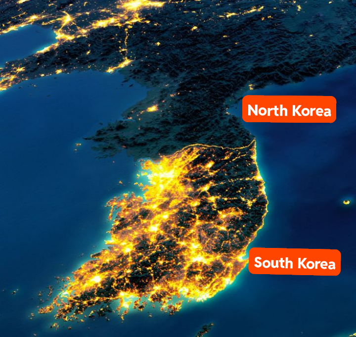
did you know they actually put those lights on just for the picture, bc no one in north korea actually has electricity. crazy.
You think they have LIGHT? They actually painted the ground white and built the buildings in the background out of wood props like a Hollywood set
More seriously, this does look quite nice
to think all those poor citizens had to learn how to perfectly paint realism just to pull this stunt… that’s so sad…

I’m just gonna leave this here
 @lemmy.ee
If we’re to believe that the entire north has no electricity outside pyongyang then the libs need to explain why the country has 80% smartphone ownership, where the mobile phone infrastructure for that comes from and where the electricity everyone charges their phones on comes from too.
in north korea every village has a communal 5000mah battery bank, which is perpetually charged by rotating slaves (normal north korean citizens) on a hamster wheel. but the thing is, the hamster wheel isn’t even big enough to run on. north korea is poor so they made it only big enough to crawl. so you have to crawl really fast on a metal wire wheel and hurt your knees and shins and stuff to. it really sucks there man.
It’s hard work after pulling the trains all day
Ok, regarding the train thing, I know it’s a meme, but trains are fucking cool. The extremely low friction coefficient between the steel wheels and the steel tracks, which are designed for minimal contact between the polished surfaces, makes it so that an average human can literally drag a train car weighing many times that of the person. Like, that’s the entire fun of trains and why we decided as humans it was worth it to lay hundreds of thousands of kilometers of steel rails, and why train freight is so fucking good and efficient compared to trucks.
So what’s with the pictures? Are there just less people? Or less light pollution for some reason?
Iirc it has to do with being unable capture satellite images or something
What I heard is that the pic has been edited to make the north look darker.
Nearly every photo showing the DPRK as having no lights at night is fake to some degree.
Now it is important to know that the North and Eastern parts of the DPRK are very mountainous so you are only going to see light on the Western/North West Coastal side mostly. That’s because that’s where all the people are.
But generally the pictures shown are from when there are blackouts, which still happen being a country under embargo, but it’s not all the time. Secondly they are usually composites, so they’ve combined multiple blackouts to make it look like there’s no lights. It like if you overlapped a whole lot of satellite photos post hurricanes and storms in the USA to suggest the USA was worse off in those regions.
Also photoshop and other exaggeration measures.
basically the military took fewer pictures and worse pictures.
So, scientists have observed Earth’s nightlights for more than four decades, first with astronaut photography and military satellites. Since the 1960s, the U.S. Air Force has operated the Defense Meteorological Satellite Program (DMSP), a series of 18 polar-orbiting satellites that observe clouds and other weather variables in key wavelengths of infrared and visible light. Starting in 1972, the DMSP satellites included the Operational Linescan System (OLS), which gives weather forecasters some ability to see in the dark.
While DMSP has been a source of nighttime images for decades, until fairly recently the data were classified, which meant that only a few civilian scientists could conveniently gain access to study the data. The atmospheric science community was eager to have a more accessible night-vision tool to better understand weather and climate patterns and phenomena. Finally, in 2011, a new source of unclassified satellite images of Earth at night became available—one that improved upon the capabilities of OLS. The new low-light sensor was called the Visible Infrared Imaging Radiometer Suite (VIIRS), and was launched in October 2011 onboard the Suomi National Polar-orbiting Partnership (NPP) satellite—a partnership between NASA, the National Oceanic and Atmospheric Administration (NOAA), and the U.S. Department of Defense
– Earth at Night
My main guess is they have less street lights. The vast majority of that light has to be street lighting and it’s just not prioritised by central planning perhaps?
Obviously the infrastructure exists for electricity if they have these other things. So a light difference must come from other factors. I’m working on the assumption these differences aren’t caused by a problem with composite images too, I do not know if there is an issue occurring there or not.
deleted by creator
Imagine thinking it’s backwards when it’s dark at night because people in the country actually get a full night’s sleep instead of working 16 hours and then going down to the well-lit neighborhood bar to get buzzed enough to actually fall asleep.
8 hours for work, 8 hours for sleep, and 8 hours for WHATEVER THE HELL WE WANT!
In North Korea they turn the fucking lights off when they go to sleep!
I love the Slammer picture where it’s zoomed in on occupied Korea and the light is Hitler holding a candle.
Receipt plz
Couldn’t find the original going through their feed, but it’s at least part of this one. https://xcancel.com/FuknSlammer/status/1723814795965575380
We need to invade and bring them advertising, such a shame
Removed by mod
Looks so nice and clean. Would love to visit one day
“Bet $5 get $200”
Juche Kings
I want to live there


