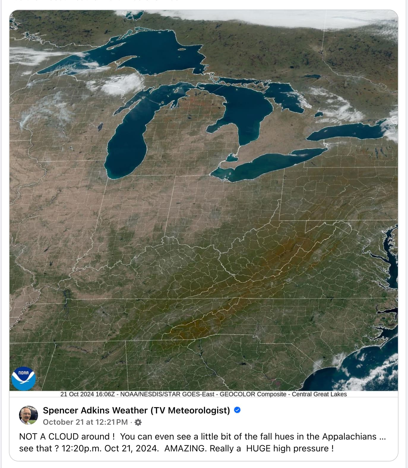
What do you mean? Those lines aren’t really there? But they are crucial to electing the president. And the one at the very bottom is important to keep the brown people out. How could they not be real?
“Roughly a trapezoid” that averages 1650 miles/2660 km across from north to south.
Edit: I just looked it up, the northernmost point is Angle Inlet, MN. The southernmost point is Key West, FL. Both are on the map. If you drove nonstop from one to the other, it would take you 36 hours.
What’s funny to me is that this is just the North to South axis, so if you want to full on go NW to SE, you can do Cape Flattery, WA to Key West, FL for a 55 hour road trip, assuming you’re on meth and have a fuel tank large enough to do 3650 miles or roughly 5870 km without stopping.
I’m now tempted to take a month off to come visit your country some time in the next few years, enjoying the best of both worlds: My 28 days of basic PTO as an Estonian, and your amazing landscapes in the US.
Of course I’m also worried that if I were to customize the route to include places actually worth visiting, rather than just stopping at gas stations and hotels, a month wouldn’t be close to enough. Just adding the Grand Canyon adds like 8 or 9 extra hours of driving!
That’s a good one too I think. I know someone who did the Moscow to Vladivostok train ride (and I’m assuming took a train or something to Moscow in the first place). He said it was pretty fun seeing the culture change so much getting out of the city and into the countryside. Russians on the whole (excluding everyone in power and many alcoholics of course) are friendly and kind, so not at all a bad country to go through. Unfortunately no longer an option for the majority of us because Putin’s an asshole.

Would be better without the grid.
What do you mean? Those lines aren’t really there? But they are crucial to electing the president. And the one at the very bottom is important to keep the brown people out. How could they not be real?
In terms of the visual beauty of it, I agree. But the grid does help people familiar with the U.S. orient themselves.
You have those big ass lakes and still need a country grid to orient yourselfes?
Believe it or not, you can’t tell whether you’re in Kentucky or Tennessee by looking at those big-ass lakes, what with them being nowhere near them.
I don’t think you have a real picture of the enormous size of the U.S.
I mean, US is roughly a trapezoid, lakes on top, mountain range left and right side… Anyway, it hinders the purpose of seeing the fall colours.
“Roughly a trapezoid” that averages 1650 miles/2660 km across from north to south.
Edit: I just looked it up, the northernmost point is Angle Inlet, MN. The southernmost point is Key West, FL. Both are on the map. If you drove nonstop from one to the other, it would take you 36 hours.
What’s funny to me is that this is just the North to South axis, so if you want to full on go NW to SE, you can do Cape Flattery, WA to Key West, FL for a 55 hour road trip, assuming you’re on meth and have a fuel tank large enough to do 3650 miles or roughly 5870 km without stopping.
I’m now tempted to take a month off to come visit your country some time in the next few years, enjoying the best of both worlds: My 28 days of basic PTO as an Estonian, and your amazing landscapes in the US.
Of course I’m also worried that if I were to customize the route to include places actually worth visiting, rather than just stopping at gas stations and hotels, a month wouldn’t be close to enough. Just adding the Grand Canyon adds like 8 or 9 extra hours of driving!
I’ve always wanted to take the East/West train route across the U.S. (while it still exists). Start in New York and end in California.
That’s a good one too I think. I know someone who did the Moscow to Vladivostok train ride (and I’m assuming took a train or something to Moscow in the first place). He said it was pretty fun seeing the culture change so much getting out of the city and into the countryside. Russians on the whole (excluding everyone in power and many alcoholics of course) are friendly and kind, so not at all a bad country to go through. Unfortunately no longer an option for the majority of us because Putin’s an asshole.
Let’s be honest, most americans can’t point their house out on a map unless it’s googlemaps.